
How Boundary Surveys Help Houston Property Owners Navigate Split Ownership and Legacy Family Tracts
Some Houston families have held onto the same land for fifty or sixty years. Grandparents bought it, parents inherited it and now several cousins or siblings share ownership without anyone being completely sure where the lines are. That situation is more common than people think, and boundary surveys are often the first step toward sorting it out before it turns into a real problem.
Reconstructing Property Histories That Span Multiple Generations
Old family land comes with old paperwork. Deeds written decades ago used different language, different reference points and sometimes descriptions that are nearly impossible to follow today. “Beginning at the old oak tree” doesn’t mean much when the oak tree is gone.
When land passes through two or three generations, the records get thinner each time. Relatives pass away. Files get lost. What the original owner knew about the property boundaries lived in their head, not in any document anyone can find now.
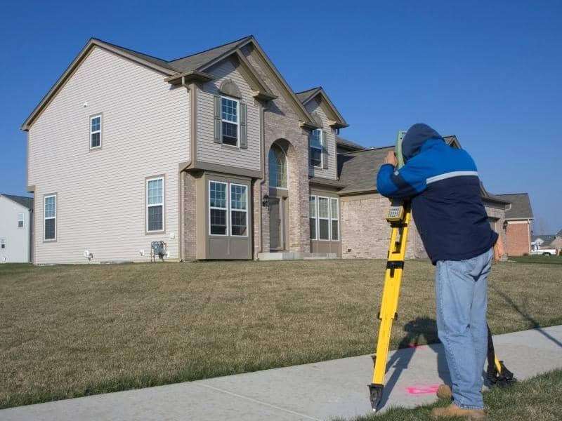
A boundary surveyor goes back to the original legal descriptions and recorded documents and works forward from there. They locate physical evidence on the ground, iron pins, fence lines, old stone markers, and match that evidence against the written record. The result is a clear picture of where the land actually starts and stops, based on real research rather than family memory.
This kind of work takes longer on old properties. But it’s the only reliable way to understand what the family actually owns before making any decisions about the land.
Understanding How Partial Ownership Interests Can Affect Land Use Decisions
Shared ownership gets complicated fast. Four siblings inherit a 200-acre tract. One wants to lease a section to a farmer. Another wants to build a small house on the back portion. A third is thinking about selling their shares. None of them can move forward confidently without knowing exactly what the property looks like and where everything sits.
Boundary information gives everyone at the table the same starting point. It shows the full size of the tract, where access points are and how the land lays out across the whole parcel. Decisions about leasing, building or selling become much easier to discuss when all owners are looking at accurate measurements rather than guessing.
Without that shared reference, conversations about the property tend to go in circles. Everyone has a slightly different idea of what the land includes, and those differences cause friction that gets worse over time.
Clarifying Boundaries When Family Land Has Been Used Differently Over the Years
Large family tracts rarely get used the same way across every acre. One corner might have a house on it. Another section has been farmed for thirty years. Part of it is wooded and nobody goes back there much. Old storage buildings sit along one fence line from a business the family ran decades ago.
All of that history leaves marks on the land. Fences get moved. Structures go up in spots that made sense at the time. Roads get worn into the ground that have no legal status but have been used so long they feel permanent.
A boundary survey shows how all of those uses fit within the actual legal limits of the property. That matters when family members disagree about which areas belong to which portion of the tract, or when someone wants to do something new and needs to know if they’re working within their own land or crossing into another section.
Some of the things a survey helps clarify on long-held family properties:
- Where old fences sit relative to the actual property line
- Which structures fall inside the legal boundary and which might not
- How access roads or driveways cross the tract and whether they connect to a public road
- Where a creek, pond or drainage feature sits in relation to the boundary
Supporting Attorneys, Appraisers, and Other Professionals Working With Legacy Properties
When a family decides to do something formal with inherited land, a lot of professionals get involved. An estate attorney needs to understand what’s being transferred. An appraiser needs accurate acreage and boundary information to value the property. A lender financing a purchase needs documentation of what’s actually there.
All of these people work better when accurate boundary information already exists. An attorney drafting a deed can describe the property correctly. An appraiser doesn’t have to estimate acreage from an old tax record that may not reflect reality. A lender can review a survey instead of asking questions nobody can answer.
Without a current boundary survey, each of these professionals has to work around the gap. That slows things down and sometimes raises questions that stop a transaction entirely while someone tries to find information that should have been documented years ago.
Creating Reliable Records for Future Generations and Long-Term Stewardship
Family land rarely stays with one generation. Eventually it passes again, and the people who inherit it may know even less about it than the current owners do. They’ll have the same questions. Where exactly is the line? What does the family actually own? What are the access points?
A boundary survey done today answers those questions for whoever comes next. The documentation doesn’t expire. A survey completed now will still be a useful starting point for the next generation, even if some additional verification is needed decades from now.
Families that invest in clear records tend to have fewer ownership disagreements over time. The information is there. Everyone can see it. Decisions about the land can be made from facts rather than from competing versions of what various relatives remember being told years ago.
That kind of documented clarity is one of the more practical things a current generation can leave behind for the people who will eventually inherit what they’ve held onto.
Frequently Asked Questions
Why are boundary surveys important for legacy family properties?
Boundary surveys provide accurate information that helps owners understand the size and location of land that has been held for many years.
Can a boundary survey help when multiple family members own the same property?
Yes. Boundary information gives all owners a shared understanding of the property’s layout and limits.
Who may use the information shown on a boundary survey?
Property owners, attorneys, appraisers, lenders, estate planners and future buyers may all rely on survey information.
Is a boundary survey useful even if the property has stayed in the family for decades?
Yes. Older properties often benefit from updated records that reflect current conditions and ownership needs.
Can different parts of a family tract be used for different purposes?
Yes. Large properties may support residential, agricultural, recreational or other uses across various sections of the land.
How do boundary surveys help future generations?
Boundary surveys create reliable records that help future owners better understand and manage inherited property.